GPR DATA PROCESSING, VISUALIZATION, AND INTERPRETATION
GRAD focuses on maximizing the information retrievable from raw data.
Designed for real-world conditions, built by practitioners for practitioners, GRAD supports multiple GPR manufacturers, integrates GPS data, and exports to typical GIS formats, giving teams the flexibility they need to work efficiently and deliver consistent, high-quality results.
GRAD combines the technical power required by geophysicists with the usability that everyday field teams need. Whether for NDT, utility locating, or academic research, it helps professionals analyze subsurface data faster, visualize with greater clarity, and interpret with confidence.
PROVEN IN THE FIELD
Powerful tools for faster, clearer GPR interpretation
GRAD streamlines the entire workflow of ground penetrating radar data processing. From import to visualization to export, every feature is designed to save time, improve accuracy, and give users full control of their data. Whether you manage small site scans or large survey datasets, GRAD delivers consistency and clarity without reliance on cloud systems or proprietary formats.
KEY FEATURES
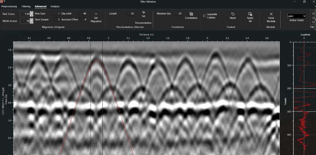
Accurate Visualization
View 2D profiles or create quasi-3D depth slices that bring clarity to complex subsurface structures.
Precision Interpretation
Adjust parameters, correct for data collection errors, and adjust amplitude settings to refine results in real time.
Universal Compatibility
Import data from multiple GPR manufacturers and export to most GIS or CAD platforms.
Designed by technicians for technicians
Built and refined by Xradar geophysicists and survey technicians for everyday use, ensuring reliability in real survey conditions.
Full Control of Data
On-premise setup keeps all data secure and locally accessible, with no reliance on remote servers or subscriptions.
Flexible Integration
Seamlessly links with GPS data, mapping systems, and project workflows for accurate spatial correlation.
PLAN PRICING
ECONOMY
Standard
Best for field-led businesses upgrading from basic manufacturer software, processing all data themselves.
Professional-grade GPR post-processing made simple. Designed for teams that want cleaner data, faster reporting, and improved scan confidence.
$1,495 / user
- self-serve TRAINING
- ESSENTIAL support
MOST POPULAR
Growth Support
Built for scaling multi-crew scanning operations seeking support from industry leaders.
Xradar becomes and extension of your team, offering post-processing support and training on a flexible basis.
$2,495 / user
- 2 hours of live onboarding
- 8 hours of professional post-processing per license
- 1-2-1 SUPPORT
Best Value
Enterprise
For large operators requiring structured rollout, standardized workflows, and deeper integration across hardware fleets.
Work with Xradar to boost your post-processing service offering. Speak to our team about custom solutions to suit your needs.
CONTACT FOR PRICING
- for 10+ users
- Custom onboarding program
- POST-PROCESSING SUPPORT PACKAGES
- Early access to new features
- Imports data from several manufacturers.
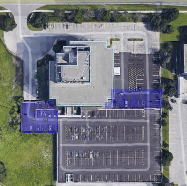
- Imports and exports shapefiles for interpretations and tracks.
- Imports shapefiles to depth slices from GPS survey data.
- Exports interpretations in several vector formats (DXF, Shapefile, KML).
- Georeferenced raster exports (.png) of depth slices and interpretations (if GPS data is available).
- Exports point and layer data as .csv files.
- Interval mapping and custom rasterized .csv export.
- KML export
- Impulse Radar (single, and multichannel).
- GSSI files (single, and multichannel).
- Screening Eagle files (single, and multichannel).
- GRAD proprietary format (*.gdt files).
- Sensor & Software data files.
- Mala files (single channel).
- IDS (single channel).
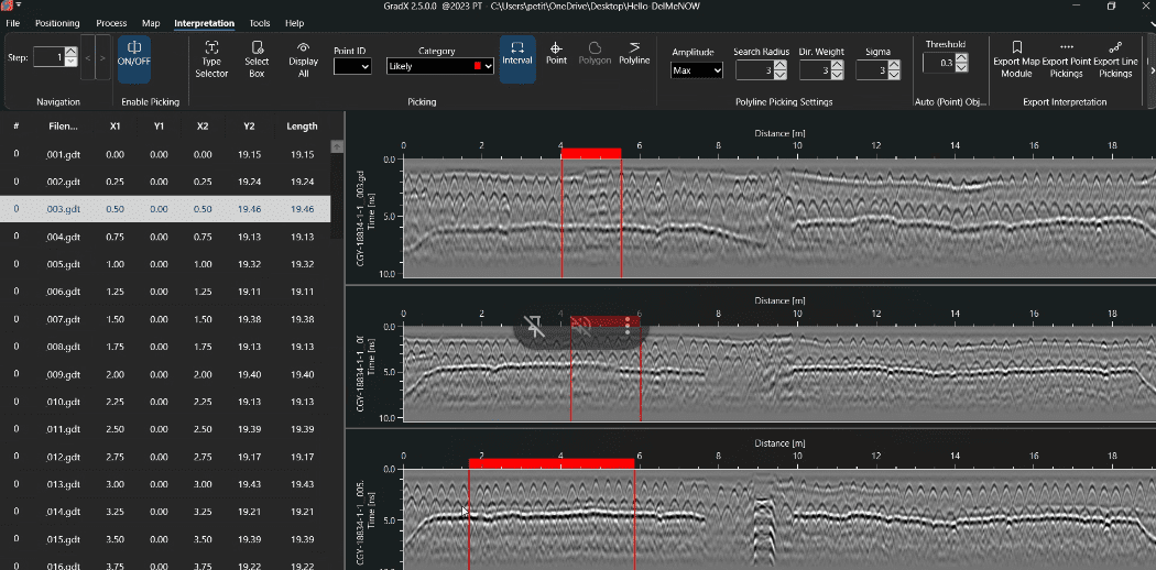
- 2D GPR profile visualization.
- Display up to three synchronized GPR profiles.
- Compare parallel scans and repeat passes simultaneously.
- Depth slice visualization of compiled 3D datasets.
- Positional view for GPS and local survey coordinates.
- Edit and correct survey positioning data.
- Vector map view of tracks and interpretations only, without radar data.
USE CASES
Where GRAD is being used
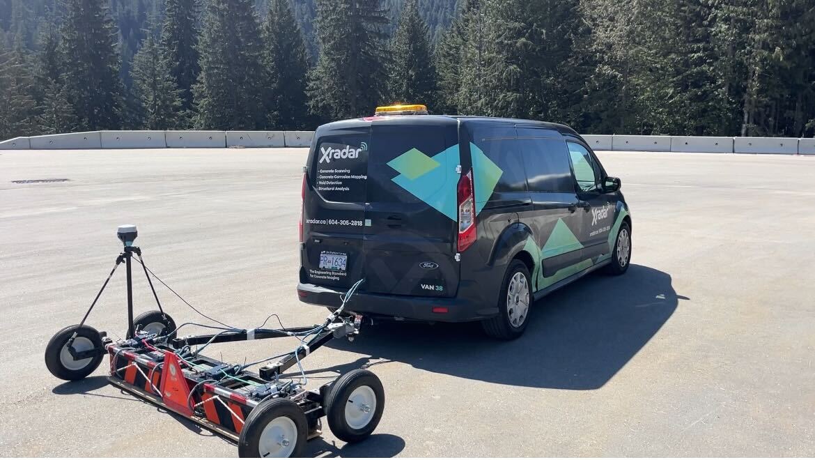
GRAD supports professionals across industries who depend on accurate ground-penetrating radar data. From research to field operations, it provides a reliable, manufacturer-agnostic platform for processing, visualizing, and interpreting subsurface information with precision and efficiency.
SHALLOW GEOPHYSICS EXPERTS
UTILITY ENGINEERING PROFESSIONALS
NDT EXPERTS
ARCHAEOLOGISTS
Feature Projects
TRUSTED BY
Trusted by professionals across GPR and shallow geophysics experts

What people say
-
GRAD allows me to give the client real, usable information. I can quickly process, then analyze the data, and produce spatial maps of the results in various formats.
If I’m performing a void survey, ultimately the client doesn’t want an augmented reality video, they want to know where the voids are across their space. GRAD does this for me, so it definitely improves the service I can provide. -
So much capability, yet not over whelming. I really like that it isn’t limited to specific GPR brands.
-
Our customers require us to provide insights behind the data we gather. GRAD is the perfect tool to help us not only do the analysis, but also explain it in a way that’s easy to understand.
-
I’ve used other tools for years such as GPR Slice and Geolitix but it’s always been a steep learning curve for our teams.
GRAD’s features range from simple data handling, to powerful auto-tagging. We often then export it into CAD and GIS for further analysis.

XRADAR ACADEMY
Enroll in our comprehensive development program in order to advance your skills in delamination detection.
Academy30-Day Free Trial
Try GRAD free for 30 days.
Full feature access. No credit card required.
✓ Import your own GPR files
✓ Evaluate workflow improvements
✓ Live onboarding included