REQUEST PROJECT ESTIMATE
Discuss your project scope with our Estimating team, for a free estimated cost.
Project EstimateLocations Offered
VANCOUVER
CALGARY
TORONTO
OTTAWA
halifax
Malaysia & Singapore
SERVICE OVERVIEW
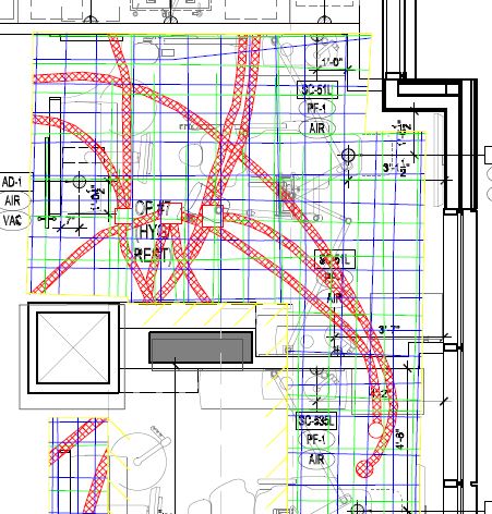
Our Pre-Design service provides architects, designers, and engineers with pre-pour layouts of rebar and conduits. This facilitates the conflict free positioning of core hole locations.
Methods & Technology
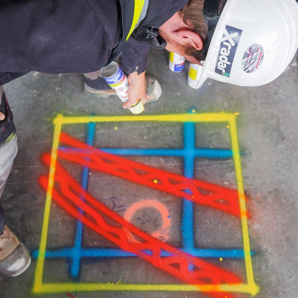
Xradar™ Enhanced Concrete Scanning
Xradar™ is an advanced imaging capability, utilizing GPR (Ground Penetrating Radar) technology that provides high-resolution subsurface imaging for safe, precise concrete scanning and utility detection.
Learn About Xradar™Laser Scanning
Laser Scanning captures exact as-built conditions for design, analysis, and documentation
Explore Laser ScanningHeading
Benefits
Ensuring Precision
with Pre-Design Scan
Multiple report outputs including AutoCAD, Revit and 3D virtual walkthrough
Highly detailed as-built drawings that include the location of all subsurface infrastructure
Create design drawings with zero conflicts
Avoid redesign costs and delays; typically $3.50 saving for every $1 spent
Explore location remotely
A space is scanned prior to the interior design phase using Xradar™, along with 3D laser scanning. A detailed AutoCAD drawing is then created, including the locations of all the subsurface infrastructure. These can be utilised by engineers or architects to create design drawings with zero conflicts.
For tenant improvement projects, Xradar™ Pre-Design Concrete Scanning has a proven record, effective at mitigating risk and adding value to projects. It’s smart space planning that enables the design team to formulate ideas and evaluate design concepts without the requirement to revisit down the line.
Virtual Site Walkthrough
A Pre-Design virtual site walkthrough allows for smart space planning, enabling the design team to formulate ideas and evaluate design concepts without the requirement to revisit sites. This means that costs are kept down and teams can design the space in the most efficient way.
Walkthroughs can be used by architects, interior designers, engineers, and across the construction industry. Capturing the project at each stage means that in-slabs targets can be documented during pre-pour, and overlaid on the finished site.
2D photography and 3D data from sites is also stitched together to create complete, immersive 3D models that can be annotated, shared and exported to programs such as Autodesk ReCap or Revit.